UPDATE: school cancelled as Typhoon 8 signal remains while Nida moves north

 Typhoon Nida is the first typhoon to shut down Hong Kong in 2016.
[Update: Tuesday, August 2, 11.00am]
While Nida has weakened into a severe tropical storm, the Typhoon 8 signal remained in effect in Hong Kong as the city stayed on high alert for flooding in low-lying areas. Meanwhile, Typhoon Nida moved away from the city and into southern China.
All primary, secondary and special needs schools closed on Tuesday, the Education Bureau announced. But a downgrade of the storm signal before 10.30am would see afternoon primary and secondary schools reopened.
Currently, the Hong Kong Observatory website states that it will issue Strong Wind Signal No.3 before 1 pm.
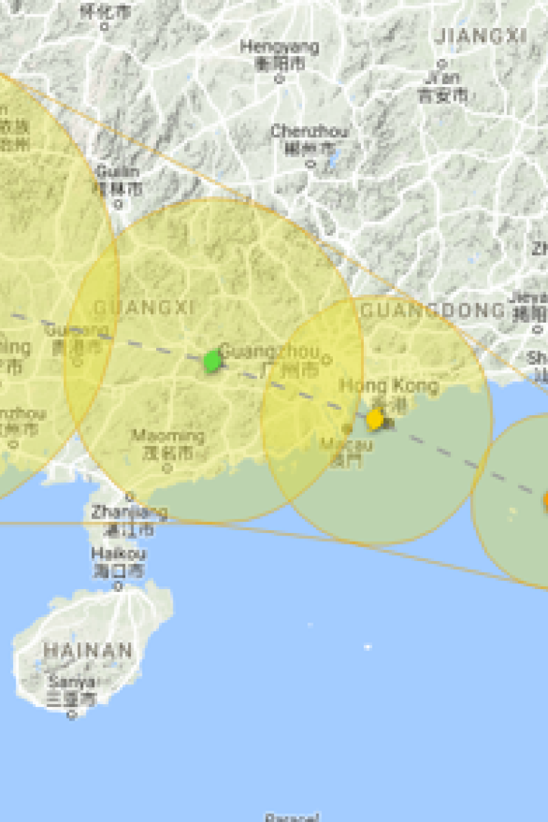
Nida, the first typhoon to shut down Hong Kong this year showed signs of slowing down as it moved inland after making landfall near the Dapeng Peninsula in Guangdong province at 4am on Tuesday.
Last night, many areas of Hong Kong was battered as the eye of the storm passed within 40km of the city. A 60mm of rain was reported.
According to the Airport Authority, about 325 flights to and from Hong Kong between 6am and 9pm were expected to be rescheduled on Tuesday. That is on top of the 156 cancelled ahead of the typhoon’s arrival on Monday.
Also, rail and MTR bus services have been adjusted, with most lines running at 10–15 minute intervals. Taxi services are also irregular, with drivers asking for cash tips for driving in this weather.
As of 9 am on this morning, the authorities were aware of 114 trees knocked down across Hong Kong, including in Tuen Mun, Sai Kung and Kowloon Tong.
[Monday, August 1]
The typhoon standby signal No 1 was raised at 10pm on Sunday night as Hong Kong braced itself for the arrival of Typhoon Nida. It is expected to bring heavy showers for a few days after it hits the city on Tuesday morning. A signal No 3 is expected to be raised by around lunchtime on Monday.
According to the Hong Kong Observatory's tropical cyclone tracker, the severe tropical storm strengthened into a typhoon as it passed over the Philippines and came closer to Hong Kong.
The storm is on track to enter a 400km radius of Hong Kong at around 2pm on Monday with wind speeds of 140km per hour.
The Observatory is advising the public to take precautionary measures. Frequent showers and thunderstorms are expected, and with temperatures ranging between 27 and 34 degrees.
“The typhoon poses a serious threat to the areas around the Pearl River Estuary,” said Queenie Lam Ching-chi, a senior scientific officer at the Observatory. “We will not rule out the possibility of issuing a stronger warning signal [after No 3].”
Clarence Fong, director of meteorological website Weather Underground, said the typhoon would possibly land within a 100km radius on Tuesday morning. However, it is still unpredictable on which side of Hong Kong it would make landfall.
Fong explained that if the storm landed to the west of Hong Kong, it would coincide with high tides. This would mean the threat of flooding in low lying areas brought about by storm surges would be significantly higher.